
Home | Personal | Outdoors | Travels | Blog | Work | Weather | Site Map
|
Home | Personal | Outdoors | Travels | Blog | Work | Weather | Site Map
|
|
|
Home | Personal | Outdoors | Travels | Blog | Work | Weather | Site Map
|
Welcome to my Longs Peak Weather and Forecast page. Since several thousand people climb Longs Peak each year including myself and many of my friends, I've created a page specifically about the weather of Longs Peak including links to the most applicable official National Weather Service forecasts. I hope you find this page useful. If you have any questions or comments, please contact me.
*** Disclaimer Statement *** By using this web page, you agree that you have read the disclaimer and assume all risk for your actions.
Quick links for this page:
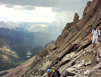
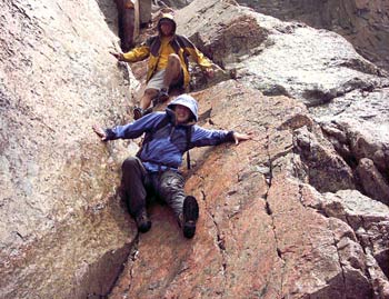
Pictures taken August 3, 2003 by Jonathan Vigh.
On average, one person dies on Longs each year, usually due to lightning or falls. The best way to stay safe on Longs Peak is to be knowledgeable about the weather, route, and do not exceed your abilities. Check with the ranger at the Longs Peak Ranger Station for current trail and route conditions. Backcountry and overnight regulations may apply.
The summit of Longs Peak reaches an elevation of 14,259 feet, rising 9000 feet above the plains to the east, and 5000 feet above the high mountain valleys to the west. Since Longs Peak pokes up so high into the free atmosphere, it often experiences weather conditions quite different from those of the lower surrounding areas. The barrier imposed by the nearby Continental Divide can sometimes contribute to severe down slope windstorms that can reach out onto the Plains or remain just at mountaintop level. However you look at it, Longs Peak can be home to some of the most extreme weather in Colorado. Some mountain climbers climb Longs Peak in the winter to train for the conditions on Everest. However, the weather can also be quite benign at other times, and even pleasant for outdoor activities.
In the summer, the summit has the coolest average temperature of any location in Colorado. On the hottest days, when temperatures on the Plains are pushing 100 degrees, the high on Longs can approach 60 degrees. Summer thunderstorms often erupt by noon or early afternoon bringing dangerous lightning, hail, rain, and even snow.
In winter, severe winds and extreme temperatures are often experienced. Longs Peak holds the record for the highest wind gust ever measured in Colorado at 201 mph! Since measurements were only taken for one winter (1981), it is likely that higher winds have ravaged the summit in the past.
Even the easiest route on Longs, the Keyhole Route (Class 3), is a technical snow climb most of the year, requiring ice axes, crampons, ropes, and experience. The Keyhole Route is usually snow-free by mid-to-late July of each year. Occasionally, the route has become snow-free in late June (drought years with hot summers), and sometimes it doesn't melt out until August. By mid-to-late September, the route usually becomes technical again.
To find out when routes on the mountain become nontechnical, call the Back Country Office of Rocky Mountain National Park. Their phone number is: (970) 586-1242. If you are in the area, you can also talk to the rangers at the Longs Peak Ranger Station, which is at the regular Longs Peak trailhead. The Back Country Office will give the standard answer "All routes on Longs Peak are technical snow climbs" or tell you which routes are non-technical. If you are planning a technical climb, you can inquire further as to the latest climber and ranger reports on route conditions. Finally, there are several web cams that look at the mountain. For a loop of current conditions, click here.
The following sites may or may not give useful conditions on Longs Peak and other routes on Northern Colorado mountains. Use at your own discretion.
Colorado Mountain School conditions update (typically updated once a week)
About zone forecasts. Weather varies from place to place, often changing dramatically from one side of a mountain to the other. Colorado is split into three National Weather Service (NWS) county warning areas, each of which has a local forecast office. The local office for Northeast Colorado is in Boulder. Each county warning area is further split into zones, which are local areas that tend to have similar weather. There are several zones that are relevant for the Longs Peak region. Usually zone 33 or zone 34 will provide the most useful information for the weather on Longs above timberline. For the weather near the trailheads, check out zone 35.
About the experimental gridpoint forecasts. Recent advances in computer and web display technology have made it possible to give forecasts valid for specific localized areas like mountain ridge tops, specific valleys, etc. This is made possible because the NWS forecast data is now entered into a high resolution nation-wide grid. The forecasts below are for the gridpoint nearest to Longs Peak, valid for an elevation of 12,995 ft. Although this information is very specific, remember that it is still subject to uncertainty. The weather can be very different from the east side to the west side. Often the change between the two sides is very pronounced at the Keyhole, with the backside usually much windier than the front side.
About the experimental graphical forecasts. The forecast for the entire region including expected snowfall, minimum and maximum temperatures, wind, and other elements can be easily seen from the graphical grid forecasts. This is very useful for seeing fronts and other changes coming in, and will help in determining how the weather could change during your expedition.
To find out what the forecasters were thinking when they made the forecast, read the Area Forecast Discussion (AFD). These are technical discussions on the factors that forecasters feel are important for the current forecast cycle.
There are currently no weather stations on Longs Peak. The nearest quality alpine observations are taken on Niwot Ridge approximately 15 miles to the south. Since both locations are just east of the Continental Divide, they often share similar weather characteristics. So when it is windy on Niwot Ridge, chances are good that it will also be windy on Longs Peak. Make sure that you check the date/time, as these pages sometimes experience outages.
Want even more information? Numerous models and upper air data are available at the UCAR-RAP Weather Pages.
Hikers and climbers from the Plains often wonder what conditions are like on the mountain compared to the weather down on the Plains. I have created a new product to show how the temperatures and winds vary with height in the free atmosphere near Colorado's Front Range. This product is derived from the twice-daily rawinsonde taken from Denver International Airport. A rawinsonde (short for radio wind sonde) is a helium or hydrogen balloon that is launched to carry weather instruments up through the lower part of the Earth's atmosphere. As these rawinsondes ascend, sometimes as high as 100,000 feet, they collect temperature, wind, humidity, and pressure data and radio it back to the launch site. Several hundred of these rawinsondes are launched twice daily around the world to gather crucial data that are used to initialize the numerical weather prediction models.
I have written a program which takes the resulting temperature and wind information and plots it in an easy-to-read format for the elevations of interest to Colorado's Front Range. The user should note that this is NOT a forecast -- this is an observation taken through a vertical profile through the atmosphere generally within 25 miles of Denver International Airport. On most days, the temperatures and winds measured out over the Plains should be somewhat similar to the values on Longs Peak at the time of the observation. Significant differences may occur when strong storm systems are moving through the region or when downslope windstorms are occurring. To be specific, during these type of patterns, the winds between 10,000 and 14,000 feet over Denver may be near calm while they may be extreme on the mountain. Actual data values from the sounding are plotted as closed black circles. Open squares indicate values of the variable that have been interpolated to altitudes of interest on the mountain. Note that no attempt has been made to correct for differences in the horizontal direction, correct for local solar heating or nighttime radiational cooling. Furthermore, no local scaling of the winds has been attempted. As I collect more data, I may try to correct for these factors in the future to try to derive values that are more accurate for the mountain itself.
Most Recent Longs Peak Sounding Loop over the past 5 days Archive
This product is scheduled to update an hour and a half after the sounding synoptic time (00Z, 12Z, and when severe weather threatens the region, 18Z). When Denver is on Daylight Savings Time, the web product will update at 7:30 PM, 7:30 AM, and occasionally 1:30 PM MDT.
Note: Your use of this product signifies that you have read the Disclaimer Statement and that you assume all risk for your actions.
Comments or questions? Please contact me.
Home | About this Site | Disclaimer || Site Map | Subscribe to be notified when new content is posted to this site
|
Home | About this Site | Disclaimer || Site Map | Subscribe to be notified when new content is posted to this site
|